V encyklopedii Allmultimedia.cz byl aktivován špičkový grafický skin Foreground.
Foreground plně podporuje – RWD, HTML 5.0, Super Galerii a YouTube 2.0 !
Foreground plně podporuje – RWD, HTML 5.0, Super Galerii a YouTube 2.0 !
Soubor:Germany1941.png
Z Multimediaexpo.cz
(Rozdíly mezi verzemi)
(Fotografie +) |
(++) |
||
| Řádka 1: | Řádka 1: | ||
| - | + | Mapa + Description: | |
| + | * English: Reichsgaue and Generalgouvernement in June 1941 | ||
| + | * Deutsch: Reichsgaue und Generalgouvernement im Jahre 1941. | ||
| + | * Français : La Pologne démembrée dans l'Europe allemande. | ||
| + | * Polski: Aneksje III Rzeszy w czasie II wojny światowej (do sierpnia 1941), linia czerwona pokazuje przebieg granicy państwowej Rzeszy 1 września 1939 (wyodrębnione również Wolne Miasto Gdańsk). Aneksje terytorialne III Rzeszy do sierpnia 1941,linia czerwona - przebieg granicy państwowej Niemiec 1 września 1939. Wyodrębniony teren Generalnego Gubernatorstwa. III Rzesza oraz terytoria anektowane i Generalne Gubernatorstwo w sierpniu 1941, linia czerwona pokazuje przebieg granicy Niemiec 1 września 1939. Aneksje III Rzeszy w czasie II wojny światowej (do sierpnia 1941), linia czerwona pokazuje przebieg granicy państwowej Rzeszy 1 września 1939 (wyodrębnione również Wolne Miasto Gdańsk). | ||
| + | * Italiano: Il Reichsgau e il Governatorato Generale nel 1941. | ||
| + | * Nederlands: Reichsgaue en het Gouvernement-Generaal in 1941. | ||
| + | * Español: Mapa de Alemania en 1941, sobre el este (derecha del mapa) el Gobierno General. | ||
| + | * 中文(简体):1941年的纳粹德国,包括帝国大区与被吞并的波兰总督府。 | ||
| + | * 中文(繁體):1941年的納粹德國,包括帝國大區與被吞併的波蘭總督府。 | ||
| + | * Norsk bokmål: Kart over Reichsgau i 1941. | ||
| + | * Čeština: Generální gouvernement na mapě Třetí říše. | ||
| + | * Tiếng Việt: Nước Đức năm 1941, bao gồm lãnh thổ của Ba Lan bị chiếm đóng. | ||
| + | * Author: Morty, Mackler, Lucius1976 | ||
| + | |||
| + | {{GFDL}} | ||
| + | [[Kategorie:Maps showing history]] | ||
Aktuální verze z 10. 4. 2025, 11:38
Mapa + Description:
- English: Reichsgaue and Generalgouvernement in June 1941
- Deutsch: Reichsgaue und Generalgouvernement im Jahre 1941.
- Français : La Pologne démembrée dans l'Europe allemande.
- Polski: Aneksje III Rzeszy w czasie II wojny światowej (do sierpnia 1941), linia czerwona pokazuje przebieg granicy państwowej Rzeszy 1 września 1939 (wyodrębnione również Wolne Miasto Gdańsk). Aneksje terytorialne III Rzeszy do sierpnia 1941,linia czerwona - przebieg granicy państwowej Niemiec 1 września 1939. Wyodrębniony teren Generalnego Gubernatorstwa. III Rzesza oraz terytoria anektowane i Generalne Gubernatorstwo w sierpniu 1941, linia czerwona pokazuje przebieg granicy Niemiec 1 września 1939. Aneksje III Rzeszy w czasie II wojny światowej (do sierpnia 1941), linia czerwona pokazuje przebieg granicy państwowej Rzeszy 1 września 1939 (wyodrębnione również Wolne Miasto Gdańsk).
- Italiano: Il Reichsgau e il Governatorato Generale nel 1941.
- Nederlands: Reichsgaue en het Gouvernement-Generaal in 1941.
- Español: Mapa de Alemania en 1941, sobre el este (derecha del mapa) el Gobierno General.
- 中文(简体):1941年的纳粹德国,包括帝国大区与被吞并的波兰总督府。
- 中文(繁體):1941年的納粹德國,包括帝國大區與被吞併的波蘭總督府。
- Norsk bokmål: Kart over Reichsgau i 1941.
- Čeština: Generální gouvernement na mapě Třetí říše.
- Tiếng Việt: Nước Đức năm 1941, bao gồm lãnh thổ của Ba Lan bị chiếm đóng.
- Author: Morty, Mackler, Lucius1976
+ pochází z Wikimedia Commons, kde má status – Permission is granted to copy, distribute and/or modify this document under the terms of the GNU Free Documentation License, Version 1.2 or any later version published by the Free Software Foundation; with no Invariant Sections, no Front-Cover Texts, and no Back-Cover Texts.
Historie souboru
Kliknutím na datum a čas se zobrazí tehdejší verze souboru.
| Datum a čas | Náhled | Rozměry | Uživatel | Komentář | |
|---|---|---|---|---|---|
| současná | 10. 4. 2025, 11:33 | 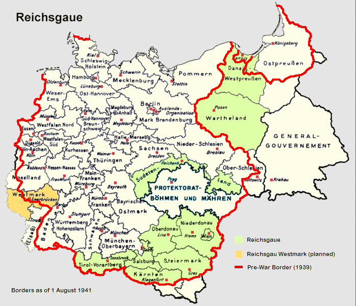 | 698×600 (240 kB) | Sysop (diskuse | příspěvky) | (Fotografie + ) |
- Editovat tento soubor v externím programu (Více informací najdete v nápovědě pro nastavení.)
Odkazy na soubor
Na soubor odkazuje tato stránka:


