Soubor:Map Norway political-geo.png
Z Multimediaexpo.cz
(Rozdíly mezi verzemi)
(Fotografie + 27 + pochází z Wikimedia Commons, kde má status –) |
(++) |
||
| Řádka 1: | Řádka 1: | ||
| - | + | Mapa + Map: Norway – geopolitical | |
| + | * Exhibits counties (fylker) of Norway (19); colours correspond to regions of Norway: | ||
| + | ** yellow: Østlandet (Austlandet) | ||
| + | ** orange: Sørlandet | ||
| + | ** red: Vestlandet | ||
| + | ** green: Trøndelag | ||
| + | ** blue: Nord-Norge | ||
| + | * Also: | ||
| + | ** violet: Svalbard; Jan Mayen | ||
| + | * Source: drawn by E Pluribus Anthony, adapted from: | ||
| + | ** Statistics Norway: This is Norway Yearbook, p. 44 (PDF) | ||
| + | ** National Geographic Xpeditions Atlas (Map Machine): Norway (PDF) | ||
| + | * Author: Mortadelo2005, Hayden120 | ||
| + | |||
| + | + pochází z Wikimedia Commons, kde má status – This work has been released into the public domain by its author, E Pluribus Anthony. This applies worldwide. | ||
| + | |||
| + | [[Kategorie:PD fotografie]] | ||
| + | [[Kategorie:Maps of Norway]] | ||
Aktuální verze z 11. 4. 2022, 15:25
Mapa + Map: Norway – geopolitical
- Exhibits counties (fylker) of Norway (19); colours correspond to regions of Norway:
- yellow: Østlandet (Austlandet)
- orange: Sørlandet
- red: Vestlandet
- green: Trøndelag
- blue: Nord-Norge
- Also:
- violet: Svalbard; Jan Mayen
- Source: drawn by E Pluribus Anthony, adapted from:
- Statistics Norway: This is Norway Yearbook, p. 44 (PDF)
- National Geographic Xpeditions Atlas (Map Machine): Norway (PDF)
- Author: Mortadelo2005, Hayden120
+ pochází z Wikimedia Commons, kde má status – This work has been released into the public domain by its author, E Pluribus Anthony. This applies worldwide.
Historie souboru
Kliknutím na datum a čas se zobrazí tehdejší verze souboru.
| Datum a čas | Náhled | Rozměry | Uživatel | Komentář | |
|---|---|---|---|---|---|
| současná | 27. 7. 2013, 11:00 | 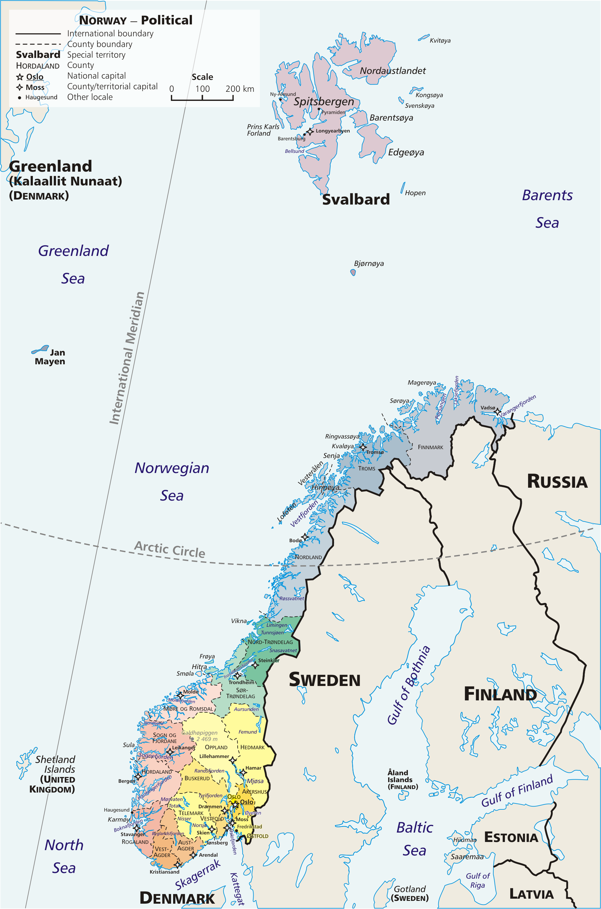 | 1 920×2 902 (924 kB) | Sysop (diskuse | příspěvky) | (Fotografie + 27 + pochází z Wikimedia Commons, kde má status – ) |
- Editovat tento soubor v externím programu (Více informací najdete v nápovědě pro nastavení.)
Odkazy na soubor
Na soubor odkazuje tato stránka:


