V pondělí 16. září 2024 začala naše další
nová soutěž o nejlepší webovou stránku !!
Proto neváhejte a začněte rychle soutěžit o lákavé ceny !!
nová soutěž o nejlepší webovou stránku !!
Proto neváhejte a začněte rychle soutěžit o lákavé ceny !!
Soubor:NZOffshoreIslandsMap.png
Z Multimediaexpo.cz
(Rozdíly mezi verzemi)
(MW1.15-Fotografie) |
(+ Doplnění) |
||
| Řádka 1: | Řádka 1: | ||
| - | + | Mapa + English: A map showing some of the outlying islands of New Zealand, including the Chatham Islands, Bounty Islands, Antipodes Islands, Auckland Islands, and Campbell Islands, as well as Australia's Macquarie Island. | |
| + | * Author: Johantheghost | ||
| + | |||
| + | + pochází z Wikimedia Commons, kde má status – Creative Commons Attribution-Share Alike 3.0 Unported license. | ||
| + | |||
| + | [[Kategorie:CC fotografie]] | ||
| + | [[Kategorie:Maps of New Zealand]] | ||
Aktuální verze z 3. 6. 2015, 01:50
Mapa + English: A map showing some of the outlying islands of New Zealand, including the Chatham Islands, Bounty Islands, Antipodes Islands, Auckland Islands, and Campbell Islands, as well as Australia's Macquarie Island.
- Author: Johantheghost
+ pochází z Wikimedia Commons, kde má status – Creative Commons Attribution-Share Alike 3.0 Unported license.
Historie souboru
Kliknutím na datum a čas se zobrazí tehdejší verze souboru.
| Datum a čas | Náhled | Rozměry | Uživatel | Komentář | |
|---|---|---|---|---|---|
| současná | 10. 4. 2014, 12:31 | 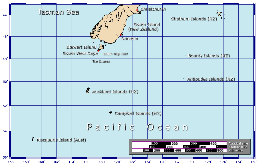 | 911×581 (76 kB) | Sysop (diskuse | příspěvky) | (MW1.15-Fotografie) |
- Editovat tento soubor v externím programu (Více informací najdete v nápovědě pro nastavení.)
Odkazy na soubor
Na soubor odkazují tyto 2 stránky:


