Soubor:Great Lakes bathymetry map.png
Z Multimediaexpo.cz
(Rozdíly mezi verzemi)
(Fotografie +) |
(++) |
||
| Řádka 1: | Řádka 1: | ||
| - | + | Mapa + English: Great Lakes bathymetry and surrounding area shaded relief map. Lakes are contoured with interval 100 m. | |
| + | * Lake Superior is incomplete. | ||
| + | * The map was created using the Generic Mapping Tools, GMT, version 5.1.1. | ||
| + | * Date: 24 March 2015 | ||
| + | * Source: Own work using: the following Public Domain datasets (grids): | ||
| + | ** Great Lakes Bathymetry from National Geophysical Data Center http://www.ngdc.noaa.gov/mgg/greatlakes/greatlakes.html. Credits: | ||
| + | ** National Geophysical Data Center, 1999. Bathymetry of Lake Erie and Lake Saint Clair. National Geophysical Data Center, NOAA. doi:10.7289/V5KS6PHK [access date: 2015-03-23]. | ||
| + | ** National Geophysical Data Center, 1999. Bathymetry of Lake Huron. National Geophysical Data Center, NOAA. doi:10.7289/V5G15XS5 [access date: 2015-03-23]. | ||
| + | ** National Geophysical Data Center, 1996. Bathymetry of Lake Michigan. National Geophysical Data Center, NOAA. doi:10.7289/V5B85627 [access date: 2015-03-23]. | ||
| + | ** National Geophysical Data Center, 1999. Bathymetry of Lake Ontario. National Geophysical Data Center, NOAA. doi:10.7289/V56H4FBH [access date: 2015-03-23]. | ||
| + | ** National Geophysical Data Center, 1999. Bathymetry of Lake Superior. National Geophysical Data Center, NOAA. [access date: 2015-03-23]. | ||
| + | ** The color palette of the depth scale was made to be more or less similar to the color palettes used on the NGDC Great Lakes maps. | ||
| + | * Author: Darekk2 using the Great Lakes Bathymetry and GLOBE tiles | ||
| + | |||
| + | {{Cc-by-sa-4.0}} | ||
| + | [[Kategorie:Maps of the United States]] | ||
Aktuální verze z 7. 7. 2020, 09:43
Mapa + English: Great Lakes bathymetry and surrounding area shaded relief map. Lakes are contoured with interval 100 m.
- Lake Superior is incomplete.
- The map was created using the Generic Mapping Tools, GMT, version 5.1.1.
- Date: 24 March 2015
- Source: Own work using: the following Public Domain datasets (grids):
- Great Lakes Bathymetry from National Geophysical Data Center http://www.ngdc.noaa.gov/mgg/greatlakes/greatlakes.html. Credits:
- National Geophysical Data Center, 1999. Bathymetry of Lake Erie and Lake Saint Clair. National Geophysical Data Center, NOAA. doi:10.7289/V5KS6PHK [access date: 2015-03-23].
- National Geophysical Data Center, 1999. Bathymetry of Lake Huron. National Geophysical Data Center, NOAA. doi:10.7289/V5G15XS5 [access date: 2015-03-23].
- National Geophysical Data Center, 1996. Bathymetry of Lake Michigan. National Geophysical Data Center, NOAA. doi:10.7289/V5B85627 [access date: 2015-03-23].
- National Geophysical Data Center, 1999. Bathymetry of Lake Ontario. National Geophysical Data Center, NOAA. doi:10.7289/V56H4FBH [access date: 2015-03-23].
- National Geophysical Data Center, 1999. Bathymetry of Lake Superior. National Geophysical Data Center, NOAA. [access date: 2015-03-23].
- The color palette of the depth scale was made to be more or less similar to the color palettes used on the NGDC Great Lakes maps.
- Author: Darekk2 using the Great Lakes Bathymetry and GLOBE tiles
+ pochází z Wikimedia Commons, kde má status – This file is licensed under the Creative Commons Attribution-Share Alike 4.0 International license. (CC BY-SA 4.0)
Historie souboru
Kliknutím na datum a čas se zobrazí tehdejší verze souboru.
| Datum a čas | Náhled | Rozměry | Uživatel | Komentář | |
|---|---|---|---|---|---|
| současná | 7. 7. 2020, 09:03 | 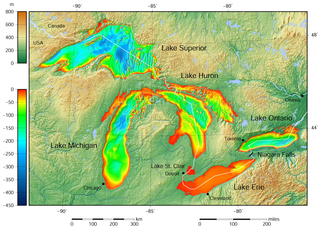 | 1 024×731 (1,34 MB) | Sysop (diskuse | příspěvky) | (Fotografie + ) |
- Editovat tento soubor v externím programu (Více informací najdete v nápovědě pro nastavení.)
Odkazy na soubor
Na soubor odkazují tyto 2 stránky:


