V pondělí 16. září 2024 začala naše další
nová soutěž o nejlepší webovou stránku !!
Proto neváhejte a začněte rychle soutěžit o lákavé ceny !!
nová soutěž o nejlepší webovou stránku !!
Proto neváhejte a začněte rychle soutěžit o lákavé ceny !!
Soubor:Saint-Barthélemy Island topographic map-de.png
Z Multimediaexpo.cz
(Rozdíly mezi verzemi)
m (Nahrazení textu „STARE01“ textem „Fotografie + + pochází z Wikimedia Commons, kde má status – Kategorie:Fotografie soutěže 2013“) |
(+ Doplnění) |
||
| (Nejsou zobrazeny 2 mezilehlé verze.) | |||
| Řádka 1: | Řádka 1: | ||
| - | + | Německá mapa + Deutsch: Topographische Karte in Deutsch des Karibischen Inselarchipels von Saint-Barthélemy. | |
| + | * English: Topographic map in French of the Caribbean archipelago of Saint Barthélemy. | ||
| + | * Français : Carte topographique en français de l'archipel de Saint-Barthélemy dans les Petites Antilles. | ||
| + | * UTM projection, WGS84 datum, scales: | ||
| + | ** Shorelines (estimated): 1:200.000 (precision: 50 m) | ||
| + | ** Topography: 1:124.000 (precision: 31 m) | ||
| + | ** Bathymetry: 1:3.700.000 (precision: 925 m) | ||
| + | * Date: 2010-08, updated 2015-10 | ||
| + | * Author: Eric Gaba (fr:Sting), German translation by Lencer | ||
| - | [[Kategorie: | + | + pochází z Wikimedia Commons, kde má status – Creative Commons Attribution-Share Alike 2.0 Generic. |
| + | |||
| + | [[Kategorie:CC fotografie]] | ||
| + | [[Kategorie:Mapy světa PNG]] | ||
| + | [[Kategorie:Maps of France]] | ||
Aktuální verze z 15. 4. 2017, 16:25
Německá mapa + Deutsch: Topographische Karte in Deutsch des Karibischen Inselarchipels von Saint-Barthélemy.
- English: Topographic map in French of the Caribbean archipelago of Saint Barthélemy.
- Français : Carte topographique en français de l'archipel de Saint-Barthélemy dans les Petites Antilles.
- UTM projection, WGS84 datum, scales:
- Shorelines (estimated): 1:200.000 (precision: 50 m)
- Topography: 1:124.000 (precision: 31 m)
- Bathymetry: 1:3.700.000 (precision: 925 m)
- Date: 2010-08, updated 2015-10
- Author: Eric Gaba (fr:Sting), German translation by Lencer
+ pochází z Wikimedia Commons, kde má status – Creative Commons Attribution-Share Alike 2.0 Generic.
Historie souboru
Kliknutím na datum a čas se zobrazí tehdejší verze souboru.
| Datum a čas | Náhled | Rozměry | Uživatel | Komentář | |
|---|---|---|---|---|---|
| současná | 14. 5. 2013, 21:59 | 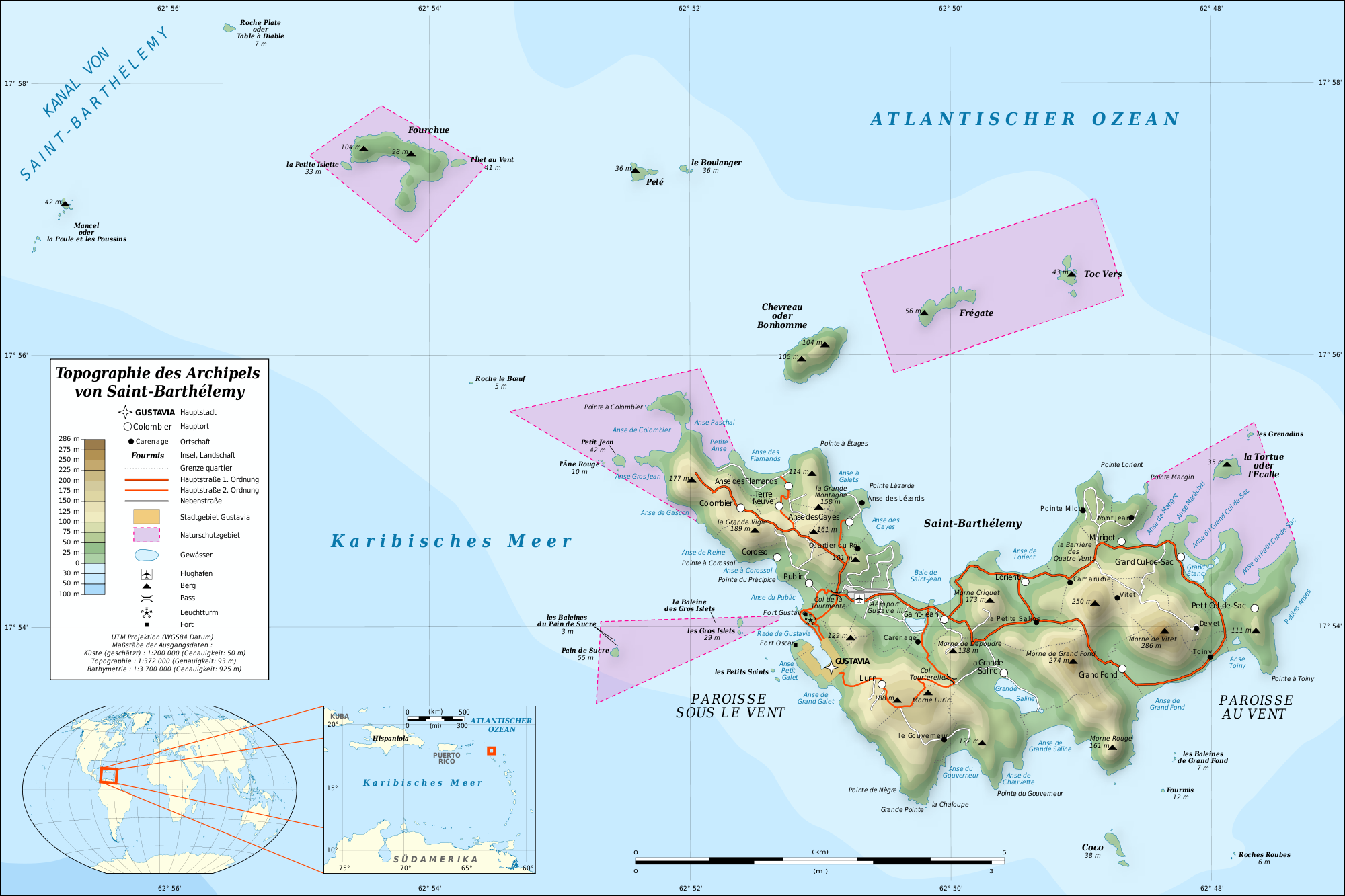 | 2 000×1 333 (841 kB) | Sysop (diskuse | příspěvky) | (Mapa + + pochází z Wikimedia Commons, kde má status – Creative Commons Attribution-Share Alike 3.0 Unported (autor: TUBS). Kategorie:CC fotografie Kategorie:Mapy světa PNG) |
- Editovat tento soubor v externím programu (Více informací najdete v nápovědě pro nastavení.)
Odkazy na soubor
Na soubor odkazuje tato stránka:


