V sobotu 2. listopadu proběhla mohutná oslava naší plnoletosti !!
Multimediaexpo.cz je již 18 let na českém internetu !!
Multimediaexpo.cz je již 18 let na českém internetu !!
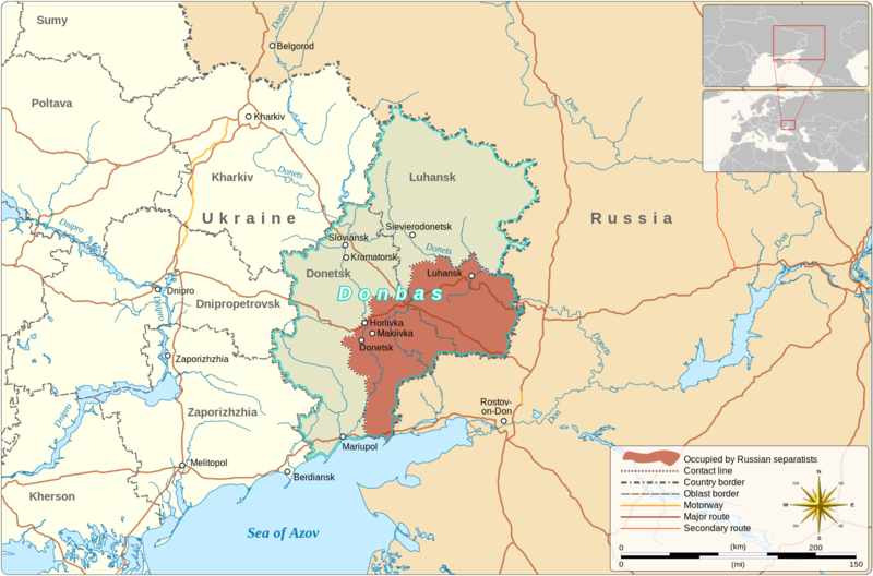
Soubor:Donbas (2015–2022).png
Z Multimediaexpo.cz

Velikost tohoto náhledu je: 800 × 528 pixelů
Obrázek ve vyšším rozlišení (rozměr: 1 523 × 1 005 pixelů, velikost souboru: 596 kB, MIME typ: image/png)
Mapa + Description:
- English: Map of the Donbas region of Ukraine, showing Russian separatist-controlled territory from the conclusion of the Battle of Debaltseve in 2015 to the outbreak of 2022 Russian invasion of Ukraine.
- Date: 9 March 2022
- Author: Goran_tek-en
- Object location: 49°02'49.2"N, 39°05'34.8"E
+ pochází z Wikimedia Commons, kde má status – This file is licensed under the Creative Commons Attribution-Share Alike 4.0 International license. (CC BY-SA 4.0)
Historie souboru
Kliknutím na datum a čas se zobrazí tehdejší verze souboru.
| Datum a čas | Náhled | Rozměry | Uživatel | Komentář | |
|---|---|---|---|---|---|
| současná | 28. 11. 2023, 14:02 |  | 1 523×1 005 (596 kB) | Sysop (diskuse | příspěvky) | (Fotografie + ) |
- Editovat tento soubor v externím programu (Více informací najdete v nápovědě pro nastavení.)
Odkazy na soubor
Na tento soubor neodkazuje žádná stránka.
