Soubor:Corrientes-oceanicas.png
Z Multimediaexpo.cz

Velikost tohoto náhledu je: 800 × 418 pixelů
Obrázek ve vyšším rozlišení (rozměr: 1 000 × 522 pixelů, velikost souboru: 75 kB, MIME typ: image/png)
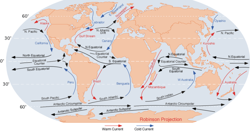
Mapa + Description: Image of the ocean currents. Note that
- E.Greenland + Labrador + Norwegian = Viking gyre
- Gulf stream + N.Atlantic Drift + Canary + N.Equatorial = Columbus gyre
- S.Equatorial + Brazil + South Atlantic + Benguela = Navigator gyre
- S.Indian + S.Equatorial + Mozambique + W. Australia = Majid gyre
- Alaska + N.Pacific + Oyashio = Aloet gyre
- Kuroshio + N. Equatorial + California = Turtle gyre
- Peru + S.Pacific + E. Australia = Heyerdahl gyre
- Finally, a few gyres also exist at the poles (not shown at this map); these are:
- North pole: Polar bear gyre, Storkerson gyre, Melville gyre
- South pole: Pinguin gyre
- References for the currents: Curtis Ebbesmeyer map at Wired
- Date: 10 August 2007
- Author: Dr. Michael Pidwirny (see http://www.physicalgeography.net)
+ pochází z Wikimedia Commons, kde má status – This work is in the public domain in the United States because it is a work prepared by an officer or employee of the United States Government as part of that person’s official duties under the terms of Title 17, Chapter 1, Section 105 of the US Code.
Historie souboru
Kliknutím na datum a čas se zobrazí tehdejší verze souboru.
| Datum a čas | Náhled | Rozměry | Uživatel | Komentář | |
|---|---|---|---|---|---|
| současná | 20. 1. 2016, 21:11 |  | 1 000×522 (75 kB) | Sysop (diskuse | příspěvky) | (Fotografie + + pochází z Wikimedia Commons, kde má status – ) |
- Editovat tento soubor v externím programu (Více informací najdete v nápovědě pro nastavení.)
Odkazy na soubor
Na soubor odkazuje tato stránka:
