Soubor:SaintVincentGrenadinenKarte.png
Z Multimediaexpo.cz
Větší rozlišení není k dispozici.
SaintVincentGrenadinenKarte.png (rozměr: 330 × 355 pixelů, velikost souboru: 17 kB, MIME typ: image/png)
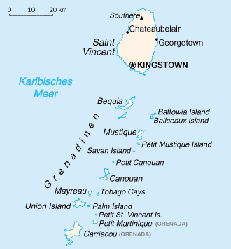
Mapa + English: Map of the Grenadines from CIA World Factbook. The Grenadines are a Caribbean island chain that belongs to either St. Vincent and the Grenadines or Barbados (2006)
+ pochází z Wikimedia Commons, kde má status – This image is in the public domain because it contains materials that originally came from the United States Central Intelligence Agency's World Factbook.
Historie souboru
Kliknutím na datum a čas se zobrazí tehdejší verze souboru.
| Datum a čas | Náhled | Rozměry | Uživatel | Komentář | |
|---|---|---|---|---|---|
| současná | 14. 5. 2013, 21:59 | | 330×355 (17 kB) | Sysop (diskuse | příspěvky) | (Mapa + + pochází z Wikimedia Commons, kde má status – Creative Commons Attribution-Share Alike 3.0 Unported (autor: TUBS). Kategorie:CC fotografie Kategorie:Mapy světa PNG) |
- Editovat tento soubor v externím programu (Více informací najdete v nápovědě pro nastavení.)
Odkazy na soubor
Na soubor odkazuje tato stránka:


