Soubor:Whitehall sketch map.png
Z Multimediaexpo.cz
(Rozdíly mezi verzemi)
m (Nahrazení textu „MW1.15-Fotografie“ textem „Fotografie + + pochází z Wikimedia Commons, kde má status – Kategorie:CC fotografie Kategorie:Fotografie soutěže 2015“) |
(Doplnění) |
||
| Řádka 1: | Řádka 1: | ||
| - | + | Mapka + Description: Sketch map of Whitehall, London, showing the position of the major UK Government buildings there | |
| + | * Date: 30 October 2005 | ||
| + | * Author: ChrisO | ||
| - | + pochází z Wikimedia Commons, kde má status – | + | + pochází z Wikimedia Commons, kde má status – Creative Commons Attribution-Share Alike 3.0 Unported license. |
[[Kategorie:CC fotografie]] | [[Kategorie:CC fotografie]] | ||
| - | [[Kategorie: | + | [[Kategorie:Maps of the United Kingdom]] |
Aktuální verze z 12. 12. 2016, 12:10
Mapka + Description: Sketch map of Whitehall, London, showing the position of the major UK Government buildings there
- Date: 30 October 2005
- Author: ChrisO
+ pochází z Wikimedia Commons, kde má status – Creative Commons Attribution-Share Alike 3.0 Unported license.
Historie souboru
Kliknutím na datum a čas se zobrazí tehdejší verze souboru.
| Datum a čas | Náhled | Rozměry | Uživatel | Komentář | |
|---|---|---|---|---|---|
| současná | 6. 4. 2014, 12:18 | 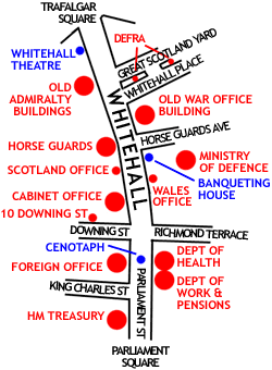 | 250×340 (17 kB) | Sysop (diskuse | příspěvky) | (MW1.15-Fotografie) |
- Editovat tento soubor v externím programu (Více informací najdete v nápovědě pro nastavení.)
Odkazy na soubor
Na soubor odkazují tyto 2 stránky:


