Soubor:Macau-CIA WFB Map.png
Z Multimediaexpo.cz
(Rozdíly mezi verzemi)
m (Nahrazení textu „MW1.15-Fotografie“ textem „Fotografie + + pochází z Wikimedia Commons, kde má status – Kategorie:CC fotografie Kategorie:Fotografie soutěže 2015“) |
(+ Doplnění) |
||
| Řádka 1: | Řádka 1: | ||
| - | + | Mapa + English: This map represents the Special Administrative Region of Macau of the People's Republic of China, formed by the Peninsula of Macau and the islands of Taipa and Coloane. | |
| - | + pochází z Wikimedia Commons, kde má status – | + | + pochází z Wikimedia Commons, kde má status – This image is in the public domain because it contains materials that originally came from the United States Central Intelligence Agency's World Factbook. |
| - | [[Kategorie: | + | [[Kategorie:PD United States]] |
| - | [[Kategorie: | + | [[Kategorie:Maps of China]] |
Aktuální verze z 11. 2. 2019, 21:48
Mapa + English: This map represents the Special Administrative Region of Macau of the People's Republic of China, formed by the Peninsula of Macau and the islands of Taipa and Coloane.
+ pochází z Wikimedia Commons, kde má status – This image is in the public domain because it contains materials that originally came from the United States Central Intelligence Agency's World Factbook.
Historie souboru
Kliknutím na datum a čas se zobrazí tehdejší verze souboru.
| Datum a čas | Náhled | Rozměry | Uživatel | Komentář | |
|---|---|---|---|---|---|
| současná | 10. 4. 2014, 11:00 | 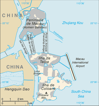 | 328×352 (20 kB) | Sysop (diskuse | příspěvky) | (MW1.15-Fotografie) |
- Editovat tento soubor v externím programu (Více informací najdete v nápovědě pro nastavení.)
Odkazy na soubor
Na soubor odkazuje tato stránka:


